World Regional Maps Coloring Book: Maps of World Regions, Continents, World Projections, USA and Canada
L**L
Mappa Mundi, in different ways
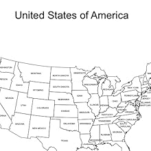
This is a useful book as a learning tool. Double copies of most outline maps are produced, and can easily be scanned or copiedThe versions offered are continent focused maps which are named and with boundaries drawn in; continent focused maps with boundaries, but the countries/regions are un-named, and continent outlines only so the student will need to draw in all countries themselves.World maps in both Mercator and Robinson Projections; Europe Global Projection; North America Global ProjectionThe Continent and Regional Maps. each with 2 copies each of the 3 versions detailed in paragraph 2 are : Africa; Antarctic Region; Australia, Oceania; Australia; Southeast Asia; Asia; Russia; Central America and the Caribbean; Central America; Europe; Europe to the Ural Mountains; Middle East; Middle East Close-up; North America; South America; Latin America; Southeast Asia to Australia; Eastern Europe; Eastern Europe - Baltic Region; Scandinavia; Mediterranean Sea Region; United States of America; CanadaAs can be inferred from the above, there is a Eurocentric bias, which may not suit everyone, but it is exactly what I wanted for a project, which my huge, weighty and expensive glossy world atlas books, one by Phillips ( a historical atlas) and one by Collins don't satisfy. It is the simplicity and very basic outline quality of borders which makes this work
A**R
Recommended
Lovely book
S**H
My son love his book
Full of options
M**A
A delight to
Very detailed. A delight to colour
C**R
Excellent idea.
Very good and ideal for teaching kids.
A**.
Good!
Good
A**R
a delightful little coloring book
a great way to learn the countries of the world. it takes each continent and you fill in the countries, a lot of fun.
.**R
Nice world colouring book
Perfect condition. Lightweight, not bulky. Nice variety of maps. Some labeled, some left blank to help with different learning techniques. I also bought an atlas to go along with this book for reference and labeling.
S**E
Fantastic!
Absolutely brilliant world maps for colouring and teaching kids about geography.
G**S
Coloring book and geo-political map resource
I use this book partly as a general atlas and partly to learn the political geography of a specific country in relation to others. There are pages with state/country borders and names, others without names, and others with just outlines of the same land mass--great learning tool!Gel pens work to color these pages--bright colors and no bleeding.
S**C
Awesome educational tool for kids
Awesome educational tool.
Trustpilot
2 days ago
1 day ago