


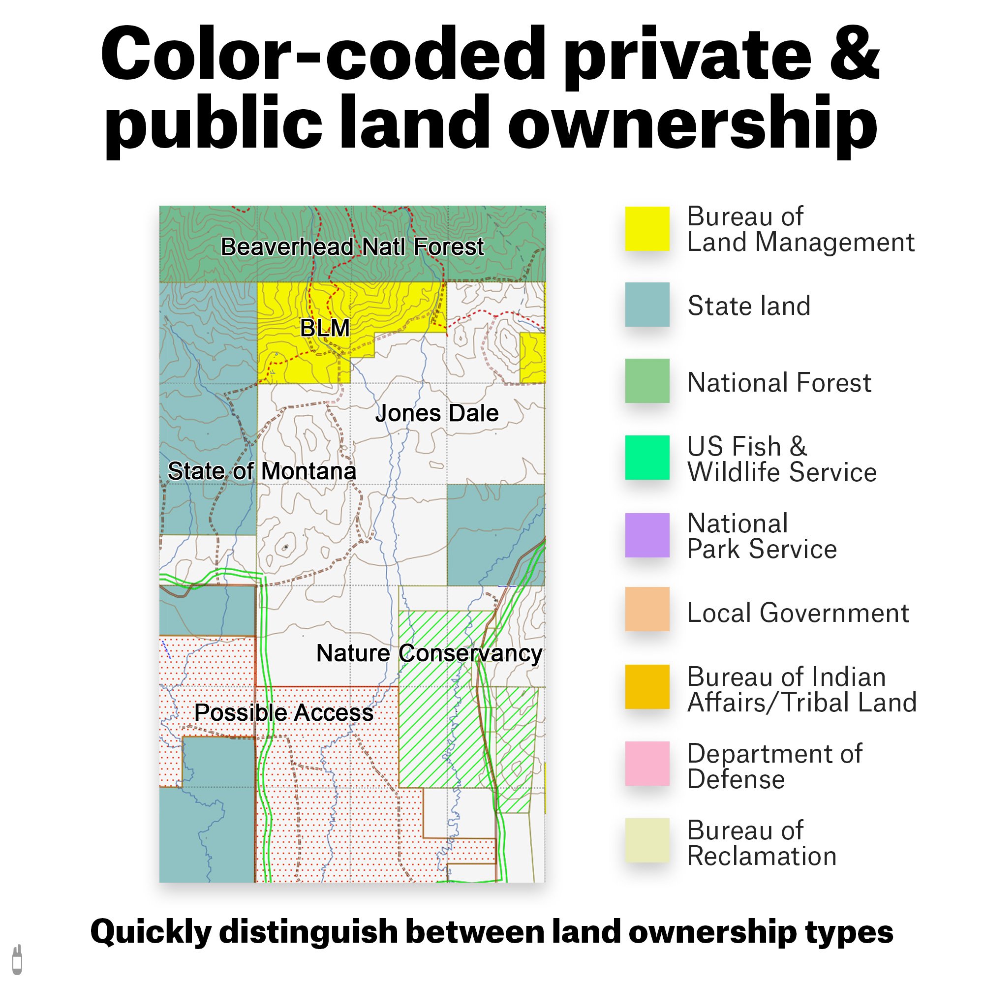
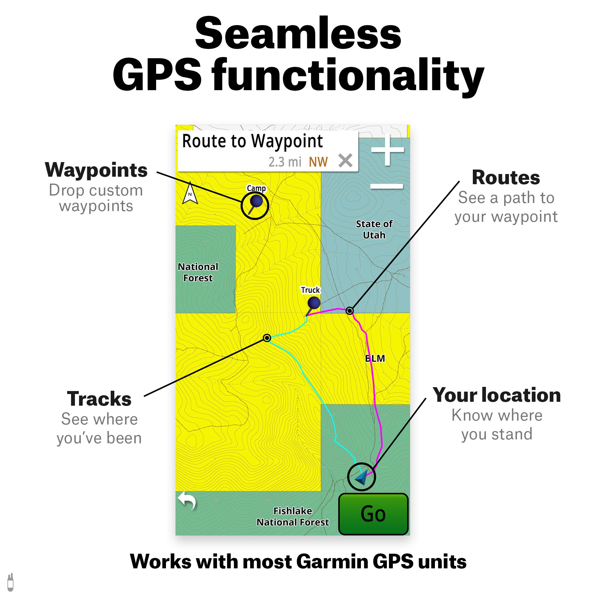

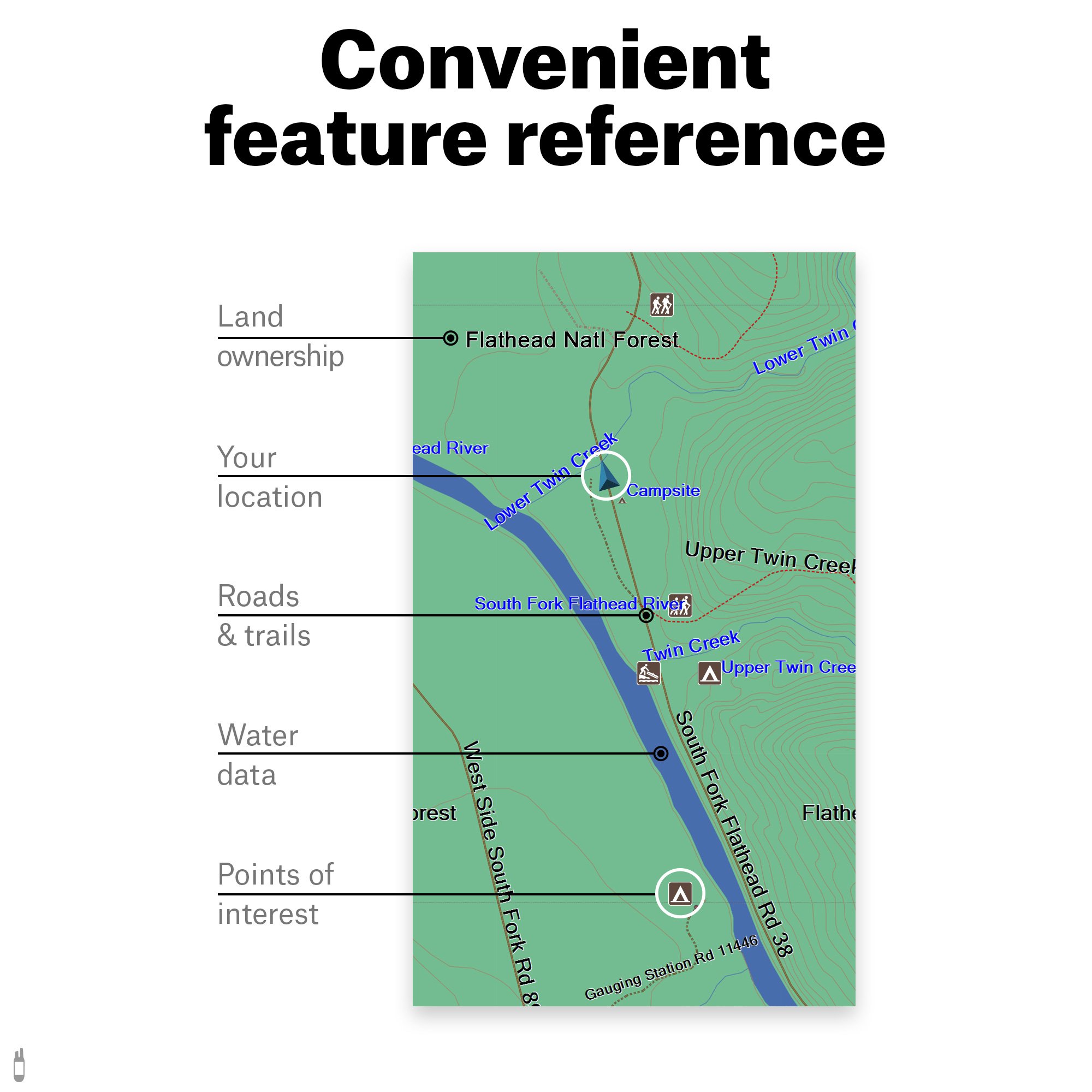
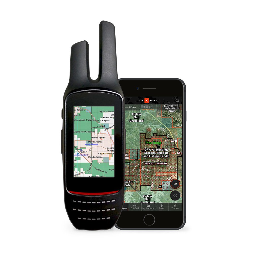
An essential tool for your hunting arsenal, these digital maps highlight public and private land owner names and property boundaries. The onX Hunt Premium maps add color-coded layers to easily view land owner names while knowing your location relative to public and private property boundaries, hunting district boundaries, roads, trails, and more! Simply add the onX Hunt Chip to your compatible Garmin GPS to get instant access to state-specific hunting map data. Activate your onX Hunt Membership and start mapping on your mobile phone, tablet, and computer! Endorsed by numerous State and Federal agencies, onX Hunt is the most reliable source for accurate land ownership hunting maps. When you buy a onX Hunt Chip you gain an onX Hunt Premium Membership as well. The Membership gives you access to the onX Hunt App, Web Map and automatic Chip Updates with product activation.
J**.
Not just essential, but mandatory!
As a California resident I know all too well how difficult it is to find good BLM hunting land that allows you to hike away from roads and get at territory that is not shot-out or over-trodden by "interstate hikers" and "200yd truck hunters"... calling BLM field offices for info, calling local fire departments for burn permits and navigating government websites... Puke... While this product doesn't give you all the information a call to a BLM office can provide and won't get your burn permit for you it does make gathering large quantities of information easier to help you focus your efforts on the right area for your upcoming hunt.Having to gather the information to put together your next adventure is almost enough to take the energy for a 3-day hunt and flush it down the toilet. Land ownership changes and Hunt zones are redrawn and only the purchase of up-to-date maps or calls to field offices will alert you to potentially criminal trespassing charges or even being arrested for poaching! This product puts information in your hands that eliminates the need to do most of that leg work...With just two or three clicks of your mouse you can scan the entire landscape of California and see all of the BLM parcels. You can see which of them have the least amount of Trail access as well as which parcels are situated deep inside a ring of private land but are still accessible to the highway. And better still, there are map functions that allow you to see how far away the center of that BLM land is from the nearest roadway... All this together equates to 4 minutes of searching potentially yielding a parcel of BLM land that is only accessible to a four to five mile hike that has water and a quick call to that local fire station might get you a burn permit.Now this is how I hunt with my pals... Your mileage may vary... But when you land a shot on an animal (that you can already see will be your coffee table conversation starter with any hunter for the next 30 Years) and you see that comversation starter jump over a cattle fence and tear off into some Farmer's land, it's amazing to be able to pull up your GPS and see the contact information for the person you are about to start begging to retrieve your game...This product comes with a free full year subscription to their pay as you go service as well as updates that can be loaded onto your memory chip and installed on your GPS... The GPS that I use is a Garmin 64st and it works beautifully... Just the maps alone are worth the purchase and the tool suite that they come with just puts this product over the top!Before I start purchasing every state map that I intend to hunt over the next year-and-a-half I might even consider paying for their one time total US coverage map because I just can't see myself going on another hunt without one of these suckers!You will not be disappointed!
C**E
and one of my best freinds had been fined by sherriff for Trespassing
Bought this because the last couple years while hunting I had been harassed by land owners while on public land, and one of my best freinds had been fined by sherriff for Trespassing, even though a game warden had stated that he was on public land, and that the land owner had illegally posted public land, and the Wyoming state land commissioner had later confirmed that the land owner had posted the no tresspassing signs ~ 200 yards onto the state land, and after words the state land commissioner said it was ok for him to post the public land, and he wasn't going to make him remove them, I decided to purchase the Wyoming Public land Map for the Garmin Etrex I had just purchased. Wyoming might seem like a big inviting place but the land owners here are the meanest nastiest people in the USA. and the law enforcement is owned by them in this state. If you plan to hunt or fish any place in this nasty state, you owe it to yourself to buy this product, to help protect yourself from this nasty land owners, judges and law enforcement officers in this place. I live in the state and work for the major government land agency and I work daily in and on and near the Basin where I hunt. If you plan on hunting public land anywhere in this beautiful hell hole of a state, whether you a resident of wyoming or an "outsider", buy this for your GPS.
S**I
Perfect for hunting, hiking and more
Plug this MicroSD card into a compatible GPS, turn it on and you're all set. I installed it in a Garmin Rino 755T and now I don't want to leave home without it. If you want to make sure you're on public land while you're hunting or hiking, this is perfect, the map is right at your fingertips even when you have no cell coverage. Between the public/private land maps on this chip and the topographical maps on the Rino I imagine it would also be pretty useful for gold prospecting out here in the desert, but I haven't tried using it for that yet. Having access to the same maps on my PC and phone is a nice bonus, too. This and the Garmin Rino I installed it into were worth every penny I paid for them.
J**R
NOW it's great!
I was shocked. After purchasing a new Garmin Montana 680T and this chip I found out there is no way to export waypoints created on the computer using the Onxmaps web mapping to the GPS! It's much, much easier to create waypoints on the much larger screen of a computer than it is on the tiny screen of the GPS, and a computer allows you to move around the map much, much more quickly.I've used Garmin Basecamp for years to create routes and waypoints to download to the GPS units on my motorcycles. It works great. I wrongly assumed that Onxmaps would have similar functionality. I contacted them and they assured me it's coming soon. When I create a waypoint on the computer it appears almost instantly on the app on my phone, but there is currently now at to easily get it to the GPS. The only realistic way is to note the coordinates of the waypoint on the computer and create a waypoint on the GPS, which is somewhat of a pain.Until there is the functionality of being able to send/download waypoints to the GPS I wouldn't recommend buying this chip. Pay for the phone app and use it on a phone or tablet so you can create waypoints or routes on your computer and have them transferred to your device.UPDATE: Wow, talk about timing! The fine folks at Onxmaps just today added the ability to export GPX files from their excellent web based mapping and save them to your computer to export to your GPS. NOW this is VERY worth having. It's so easy to place waypoints using a large computer screen, and now it's also easy to export those waypoints to your GPS. BRAVO Onxmaps!!!
Trustpilot
3 days ago
4 days ago