🌍 Navigate Your World with Style!
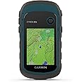
The Garmin eTrex 30x is a compact handheld GPS navigator designed for outdoor enthusiasts. It features a 2.2-inch sunlight-readable color display, 3.7 GB of internal memory for maps, and built-in sensors including a 3-axis compass and barometric altimeter. With wireless connectivity, you can easily share your adventures with others, making it an essential tool for camping and hiking.
| Item Weight | 4.96 ounces |
| Item Dimensions L x W x H | 2.1"L x 4"W x 1.3"H |
| Memory Storage Capacity | 3.7 GB |
| Display Type | 65K color TFT |
| Human-Interface Input | Touchscreen |
| Control Method | Touch |
| Are Batteries Included | No |
| Connectivity Protocol | ANT+ |
| Sport Type | Camping & Hiking |
| Audio Output Mode | Stereo |
| Battery Average Life | 25 Hours |
| Mount Type | Dashboard Mount, found in image |
| Resolution | 240 x 320 |
| Compatible with Vehicle Type | Car |
| Screen Size | 2.2 Inches |
| Additional Features | Wireless Connectivity |
| Connectivity Technology | ANT+ |
| Map Types | City Tour |
L**L
Excellent Unit--Great Price for the Features
I use several different types of Outdoor GPSs. Mostly Garmin. This unit was purchased as a loaner for hiking-hunting friends. I mainly use the free TOPO Maps for Virginia (http://www.gpsfiledepot.com/maps/view/432/, however, I also use a 2008 Garmin TOPO DVD $)..With Garmin Basecamp (the free SW program to manage maps, waypoints, etc., I had little trouble transferring my maps, waypoints (dozens), and routes (11 of them). Everything worked well. (I think Basecamp is OK, but not as good as the older Garmin MapSource v6—discontinued.).This GPS loads quickly (considering my map sizes) and locks on satellites in a reasonable amount of time. The menus are customizable (click through selected pages) which allows you to set up the GPS to quickly flip through the pages you usually use (this is common to Garmin GPSs, I think). Pages have easy to update settings for selecting fields, changing maps, and contextual options. You can also change the datum sets and the coordinate systems to your liking (to match the map-set features of your mapping software or Google's mapping system for example. You can easily edit/move/change waypoints/routes and names, and change symbols, DIRECTLY on the unit's actual database using Basecamp--a great plus for units without a touch-screen. (note: Basecamp also allows backup of the unit's data to your computer hard disk.).These newer units using GLONASS satellite association alongside US satellites, seem to place locations more accurately and more quickly than previous systems (you have to manually turn on the GLONASS setting from the menu)..The 4 GB of internal memory was enough to load my Eastern TOPO 2008 (4 States) + my Free Virginia TOPO map set without using a microSD card. The screen is clear and very usable when zooming down to 800-foot scale or higher. Once you allow Basecamp to compile and build Map image files, you can just copy them via USB connection to your hard-drive; and then, copy them to another unit (use extreme care if you do not understand what map image files are, or which directory to place them in on the Garmin unit. My second unit fired up, the first time, correctly loading my 2 map image files—without a hitch—just after I simply copied the 2 Map Image files from my HDD to the unit. (note: the unit apparently uses a slow USB 2.0 connection, so it took about 20 minutes to copy these 2 image files--about 2GBs total. Fortunately, you rarely have to copy maps/map image files).I was planning on replacing my old Garmin GPSMAP 60CSx with another similar GPS, but after using this unit, I bought a second one a couple of weeks later.) The screen is smaller than many other more expensive units, but very usable. Great handheld Product!- - -.Note: I would rate GPS unit use, GPS SW, Unit Setup, hiking uses, map-building, waypoint/route building and use, and Datum/Coordinate changes among the most difficult-to-understand software technologies for the typical consumer. I have seen many reviews and negative comments that reflect a misunderstanding about the capabilities of a handheld GPS, or realistic expectations about GPS systems/GPS software / or ridiculous commentary (bought a non-touch screen unit and complaining about lack of a touch screen). All of my Garmin units are accurate within 30 feet or less (according to the satellite fix on the screen) and have always placed me within 30 Yards of a marked waypoint months or years later (<90 feet max--which is close enough to see your stand or car). If you are new to using GPSs, or struggling to get it to work well, there are numerous websites offering information on general GPS setup and technology, and very specific information on building your own map sets, Datum/Coordinate selection, accuracy expectations, over-zooming issues, etc. and explanations about bearing/heading – placement accuracy/waypoint averaging – compass calibration – magnetic N compass alignment – vector turns, etc. I hope this helps some of you planning to tackle hand-held GPSs. . .
J**E
This works much better than my old Magellan
This works much better than my old Magellan, many more functions and boots up and finds the satellites much faster. Color screen, back track, bread crumbs, time and distance, compass, and many other functions. We do a lot of back country hiking and this works great, park your car at the trail head, turn it on and press create waypoint, and take off, it knows where your car or camp is and will always bring you back, either the same track you used or direct path. Small, light weight, and easy to read. Maps are expensive so do yourself a favor and get the FREE Garmin compatible maps from Gmaptool (google it amazon won't allow links) These topo maps are more detailed, and provide a full range of OSM data, U.S. Geological Survey Land Cover Woodland, NOAA depth contours, elevation data DEM, 3 arc second resolution (SRTM and Viewfinder Panoramas), 25m contours lines, marine objects, geographical names in English or transliteration, address search. and are routable, and did I mention FREE!
J**D
Good for custom maps
Took me about 5 hours to figure out custom maps on the device. Make sure each one is less than 3MB and that the name has no spaces. Once I was able to start creating custom maps, this has worked like a charm. Internal memory is decent. I have yet to fill it up. If you do you can use a micro sd card for additional storage. Electronic compass is accurate and it acquired location very quickly when turning on. The battery life was around 18 hours when I tested it. Only issue I have seen so far is the maps take a little time to load if you are moving fast (in a car) or if you are scrolling around with the pointer. Over all for the price and what it does, I am happy and wound recommend to anyone who wants a color map gps with out all the extra features most high end gps have now.Update: After using in the field quite a bit, I noticed the compass stops functioning after about 2-3 hours of use. Location is still accurate and no issues with it freezing, but you might want to take a compass with you.
Trustpilot
3 weeks ago
2 days ago